Build a lasting personal brand

New Remote Sensing Methodology Enhances Environmental Monitoring and Urban Planning

By Burstable Editorial Team

TL;DR

The new time series analysis technique promises unprecedented insights into environmental changes, providing an advantage for those in environmental conservation and urban planning.

The innovative methodology integrates multi-source data and advanced data reconstruction and fusion methods to enhance the precision and efficiency of remote sensing for monitoring environmental changes.

This method has the potential to revolutionize remote sensing applications, playing a crucial role in addressing climate change and other global challenges, making tomorrow better than today.

The integration of Long Short-Term Memory (LSTM) networks and Generative Adversarial Networks (GANs) has resulted in a cleaner, more accurate time series dataset, setting a new benchmark in the field of remote sensing.

Found this article helpful?

Share it with your network and spread the knowledge!

New Remote Sensing Methodology Enhances Environmental Monitoring and Urban Planning

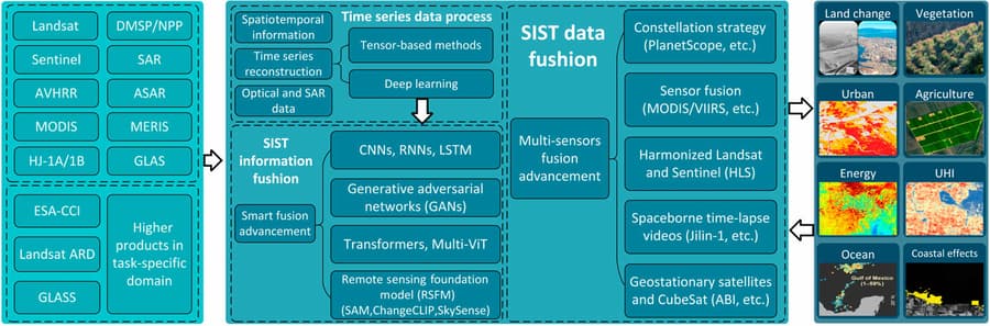
A recent study published in the Journal of Remote Sensing introduces a groundbreaking methodology for remote sensing time series analysis, combining deep learning algorithms with conventional techniques to significantly enhance the monitoring of environmental changes. This innovative approach, developed by an international team of researchers, leverages Long Short-Term Memory (LSTM) networks and Generative Adversarial Networks (GANs) to improve the accuracy and reliability of terrestrial monitoring data.

The integration of LSTM networks and GANs addresses common challenges in remote sensing, such as data gaps and atmospheric distortions, by capturing temporal trends and generating synthetic data to fill in missing information. This dual methodology has been validated against independent ground measurements, showing notable improvements in vegetation indices like the Normalized Difference Vegetation Index (NDVI). Such advancements are crucial for applications in agricultural surveillance, urban planning, and environmental management, where precise and timely data is essential.

The implications of this research are vast, offering a new tool for policymakers and scientists to better understand and respond to environmental dynamics. With the support of the National Nature Science Foundation of China, this technology is poised to play a key role in addressing global challenges such as climate change and sustainable development. The study, available for further review with the DOI:10.34133/remotesensing.0285, represents a significant leap forward in remote sensing technology, promising to revolutionize how we monitor and protect our planet's ecosystems.

Curated from 24-7 Press Release

blockchain registration record for this content
Burstable Editorial Team

Burstable Editorial Team

@burstable

Burstable News™ is a hosted solution designed to help businesses build an audience and enhance their AIO and SEO press release strategies by automatically providing fresh, unique, and brand-aligned business news content. It eliminates the overhead of engineering, maintenance, and content creation, offering an easy, no-developer-needed implementation that works on any website. The service focuses on boosting site authority with vertically-aligned stories that are guaranteed unique and compliant with Google's E-E-A-T guidelines to keep your site dynamic and engaging.